

Accessing the information in its original presentation required a very complicated and impractical process. If you were looking for a particular block, street or plot, it could take you a long time. The original indexes did not match the file structure created during the 2006 digitalization so looking for anything entailed a process of trial and error for each browse.
That is way I decided to re-organize the information in a simple and intuitive way.
All the volumes are stored in single folders, each with its index built over an overlay of the city’s modern map.
In this section I uploaded all the indexes to show the area covered by the cadaster (and those blocks that do not have an image or lacks the lot’s owner information).
By buying the cadaster you will receive all the images and the indexes shown here.
GENERAL INDEX
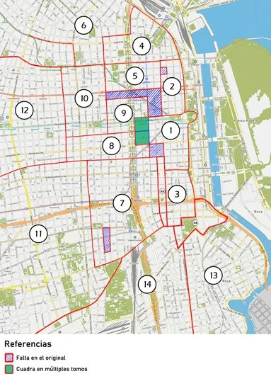
This map shows the area covered by the whole cadaster. Each number denotes the volume.
There are a few blocks that were missing in the original books or on the 2006 digitalization. Those blocks are marked in blue.
There is also a curios case of 8 blocks that are repeated in a couple of volumes, which were made 10 years apart. Those blocks are marked in green.
Click on the image to enlarge.

VOLUMES INDEXES

VOLUME 1
Catedral al Sur
Click on the image to enlarge

VOLUME 2
Catedral al Norte
Click on the image to enlarge

VOLUME 3
San Telmo
Click on the image to enlarge

VOLUME 3
San Telmo (2)
Click on the image to enlarge

VOLUME 4
El Socorro
Click on the image to enlarge

VOLUME 5
San Nicolás
Click on the image to enlarge

VOLUME 6
Pilar
Click on the image to enlarge

VOLUME 7
Concepción
Click on the image to enlarge

VOLUME 8
Monserrat
Click on the image to enlarge

VOLUME 9
San Miguel
Click on the image to enlarge

VOLUME 10
Piedad
Click on the image to enlarge

VOLUME 11
San Cristobal
Click on the image to enlarge

VOLUME 12
Balvanera
Click on the image to enlarge

VOLUME 13
La Boca
Click on the image to enlarge

VOLUME 14
Barracas al Norte
Click on the image to enlarge
